

Discover how SpatiX H7 SLAM technology is transforming the surveying and mapping industry with unparalleled precision and efficiency

Revolutionizing Surveying with Lightweight Design
In the dynamic world of surveying and mapping, precision and efficiency are paramount. The SpatiX H7 SLAM stands out as a game-changer with its lightweight design, weighing only 1kg. This remarkable portability makes it ideal for single-person operation, ensuring convenience and ease of use in various field scenarios.
The lightweight nature of the SpatiX H7 SLAM not only reduces physical strain on operators but also minimizes the learning curve. Professionals can deploy and use the device rapidly, even in challenging conditions. This efficiency translates to quicker project completions and higher productivity, making the SpatiX H7 SLAM a vital tool for modern surveying.
Achieving Real-Time 3D Modeling for Faster Project Cycles
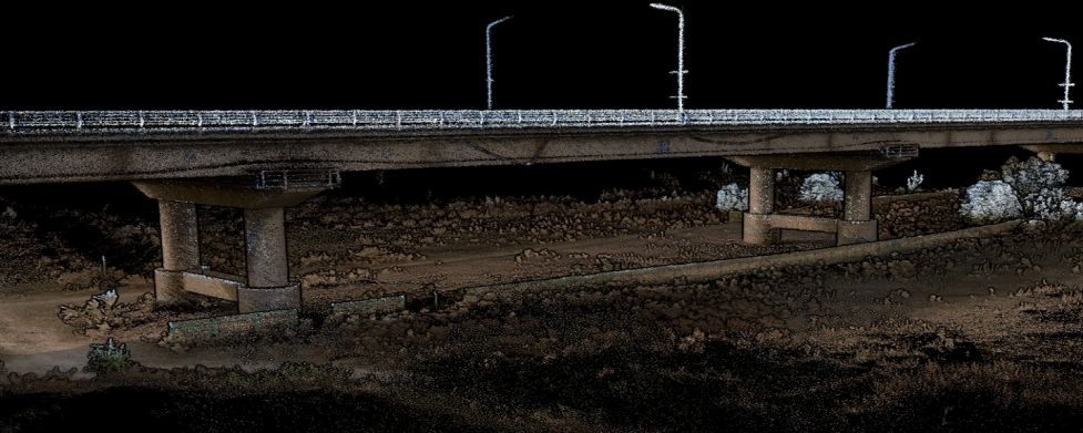
Efficiency is a critical consideration in any surveying and mapping project. The SpatiX H7 SLAM excels in this area with its real-time 3D modeling capabilities. This advanced technology allows the device to quickly generate a three-dimensional point cloud model, providing immediate feedback on surveying results.
Real-time data enables swift adjustments and informed decision-making, significantly improving overall project efficiency. By reducing the time required to obtain accurate data, the SpatiX H7 SLAM shortens project cycles and enhances productivity. Professionals can complete their tasks more quickly and with greater confidence, knowing they have access to precise and up-to-date information.
Exceptional Performance in GPS-Denied Environments
Traditional surveying methods often fall short in environments where GPS signals are weak or non-existent. The SpatiX H7 SLAM rises to the challenge with its ability to operate flawlessly in GPS-denied environments. For underground pipe galleries, mine shafts, and other areas with weak or no GPS signal, this device offers a reliable and accurate solution.
Leveraging advanced SLAM (Simultaneous Localization and Mapping) technology, the SpatiX H7 SLAM provides precise and reliable data collection, even in the most demanding conditions. This adaptability ensures that professionals can achieve accurate results without the limitations imposed by GPS signal availability, paving the way for more efficient and effective surveying and mapping projects.
Versatile Operation Modes for Diverse Applications
The flexibility of the SpatiX H7 SLAM is further enhanced by its ability to switch between multiple operation modes seamlessly. Whether conducting an aerial survey with a UAV or performing surface scanning with SLAM and RTK technologies, this device adapts effortlessly to meet the demands of diverse job scenarios.
This versatility ensures that professionals can rely on the SpatiX H7 SLAM for a wide range of applications, from architectural drawing to detailed forestry mapping. Its capability to function without GPS signals makes it an invaluable tool for underground pipe galleries, mine shafts, and other areas with weak or no GPS signal.
Ensuring Safety with Non-Contact Measurement
Safety is a paramount concern in surveying and mapping, especially in hazardous environments. The SpatiX H7 SLAM addresses this concern with its non-contact measurement capabilities, allowing professionals to collect data without the need for physical contact. This feature is particularly valuable in dangerous areas where climbing or direct interaction may pose significant risks to personnel.
The SpatiX H7 SLAM's non-contact measurement ensures that surveyors can safely gather data from a distance, minimizing the risk of accidents and injuries. This capability not only enhances safety but also increases the efficiency of data collection, as professionals can work more quickly and confidently in challenging conditions.
Unmatched Performance in Low-Light Conditions
In many surveying and mapping scenarios, lighting conditions can be less than ideal. The SpatiX H7 SLAM excels in low-light and dark environments, thanks to its advanced technology that does not rely on visible light. This capability ensures that the device can operate effectively in a wide range of conditions, from dimly lit tunnels to densely forested areas where sunlight may be limited.
By providing reliable performance in low-light and dark environments, the SpatiX H7 SLAM expands the possibilities for surveying and mapping projects. Professionals can confidently tackle challenging scenarios, knowing that their equipment will deliver accurate and dependable results, regardless of lighting conditions.
The SpatiX H7 SLAM is a revolutionary tool in the field of surveying and mapping. Its lightweight design, versatile operation modes, and exceptional performance in GPS-denied environments make it indispensable for architectural drawing, forestry, and tunnel surveying. With real-time 3D modeling capabilities and non-contact measurement, the SpatiX H7 SLAM enhances efficiency, safety, and accuracy across various challenging scenarios. Trust in the innovative, driven, and trustworthy technology of the SpatiX H7 SLAM to revolutionize your surveying and mapping projects.
